L'Étape du Tour de France 2026: Complete Route Analysis from Le Bourg-d'Oisans to Alpe d'Huez
.png)
L'Étape du Tour de France 2026: Complete Route Analysis from Le Bourg-d'Oisans to Alpe d'Huez
An exceptional 170-kilometre challenge with 5,000 metres of climbing across four legendary Alpine cols
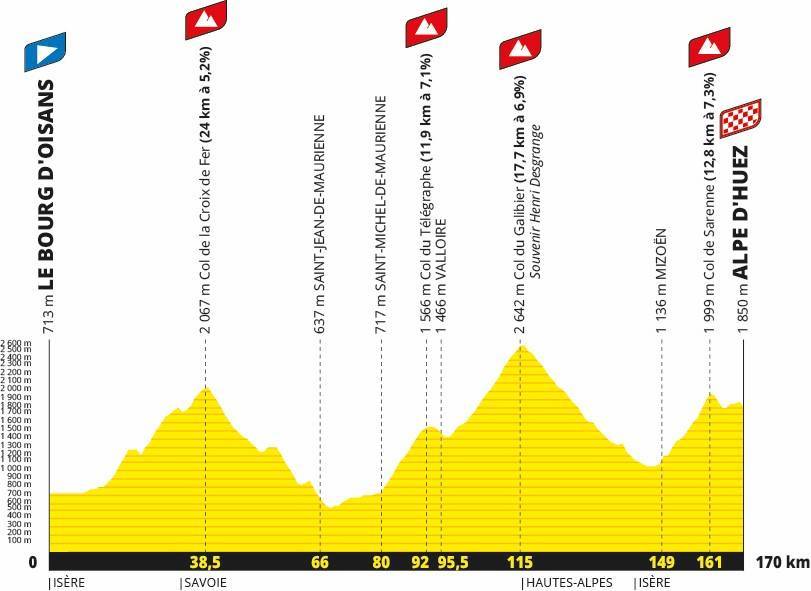
On 19 July 2026, L'Étape du Tour connects Le Bourg-d'Oisans to Alpe d'Huez across a formidable 170-kilometre route. This edition marks a return to exceptional Alpine challenges with four major cols: the Croix de Fer, Télégraphe, Galibier and Sarenne. This combination promises a day of intense effort and unforgettable sensations through France's most beautiful mountains.
At Baroudeur Cycling, we offer a comprehensive package with guaranteed race entry to experience this legendary stage in optimal conditions. Founded by Jérôme Cousin, former professional World Tour cyclist who raced multiple Tours de France, we bring genuine expertise to this extraordinary challenge. Discover our other cycling holidays in France exploring more mythical cols.
Technical Data: The 2026 Route Challenge
General Characteristics
The 2026 edition presents particularly demanding characteristics making it one of the toughest stages in this popular event's history:
Total distance: 170 kilometres precisely measured
Total elevation gain: Approximately 5,000 metres (excluding tunnels)
Average altitude: 1,500 metres constant elevation
Major cols: 4 ascents, with 3 exceeding 2,000 metres
High altitude exposure: 45% of the route above 1,500 metres
This 2026 edition features significantly more climbing and distance than recent editions. The distance-to-elevation ratio reaches exceptionally high levels with long ascents consistently located at high altitude. Participants must manage not only intense physical effort but also the physiological effects of altitude.
Crucial data: Above 1,800 metres altitude, available oxygen decreases significantly (approximately 15% less than sea level). Your body must adapt to these hypoxic conditions. Effort management becomes absolutely critical to avoid complete breakdown. Learn how to fuel properly for long-distance cycling with our comprehensive guide.
Col de la Croix de Fer (2,067m): First Major Challenge
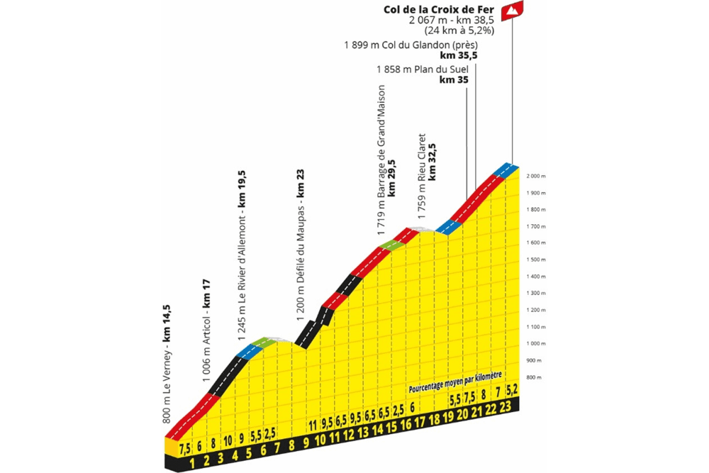
Detailed Technical Characteristics
Distance: 29 kilometres from Allemond (24km actual climbing)
Elevation gain: 1,600 metres cumulative
Average gradient: 5.2% overall
Primary difficulty: Irregular profile with intermediate descents breaking rhythm
Detailed Ascent Description
The start occurs in Le Bourg-d'Oisans, the cycling capital of the Alps. The first 7 kilometres follow the D1091 towards Rochetaillée. At this strategic junction, the route turns right into the narrow Eau d'Olle valley, abandoning the Alpe d'Huez road for wilder territory.
First section: To Rivier-d'Allemont
After passing the impressive Verney dam with its turquoise waters, the climb begins properly. An initial S-bend ramp allows finding your rhythm before several relatively flat kilometres alongside the artificial lake. The atmosphere changes dramatically after the hamlet of Articol: gradients sit consistently between 9 and 10% for several kilometres, already testing fresh morning legs.
A technical 2-kilometre descent in hairpins precedes the next section. This portion always surprises participants, brutally breaking the ascending rhythm. Concentration remains necessary despite the morning freshness.
Second section: Towards Grand'Maison dam
After this descent, the road immediately presents 300-400 metres between 12 and 14%. This represents the steepest passage on the entire Col de la Croix de Fer. The lightest gears become essential. The road then winds progressively up to Grand'Maison dam (1,700 metres altitude).
This exposed zone around the dam features moderate gradients at 4-6% but strong crosswinds can significantly complicate progress. Altitude begins making itself felt with slightly accelerated breathing.
Strategic refuelling point: Grand'Maison dam constitutes a crucial location for proper feeding and refilling all available bottles. The next opportunity comes at the Télégraphe summit, over 50 kilometres away.
Third section: Final kilometres to summit
The final 6 kilometres present steady gradients between 5 and 7%. The landscape progressively opens onto high-altitude pastures with magnificent views of surrounding peaks. The col summits at 2,067 metres altitude, the first excursion above 2,000 metres of the day.
Recommended gearing: 34x32 minimum to manage the 12-14% passages. Compact 50/34 chainsets with 11-32 or 11-34 cassettes prove perfectly suited to maximum gradients. Less experienced cyclists will appreciate an 11-36 cassette offering additional margin.
Technical Descent to Saint-Jean-de-Maurienne
The descent covers approximately 30 kilometres in three distinct phases requiring vigilance and technique:
First 7 kilometres to Saint-Sorlin-d'Arves: Winding road with numerous tight bends. Caution proves essential on this sometimes irregular surface. Cold temperatures at altitude necessitate a windproof gilet to avoid excessive cooling.
Middle portion: More flowing section with a surprise 1-kilometre climb at 7% maximum (legs feel it after the long descent) and passage through a short tunnel requiring lighting.
Final descent: Long, fast, flowing descent to Saint-Jean-de-Maurienne with speeds easily exceeding 70 km/h. Concentration remains maximal despite mounting fatigue.
Water point: Fountain available outside Saint-Sorlin-d'Arves town hall for refilling bottles. Use it systematically. Our endurance climbing tips include crucial hydration management.
Valley Transition: 13 Strategic Kilometres
From Saint-Jean-de-Maurienne to Saint-Michel-de-Maurienne, the route follows a false flat upwards for 13 kilometres (approximately 700 metres altitude). This apparently innocuous section plays a crucial role in overall effort management.
Tactical Objectives for This Section
Feed regularly and conscientiously: Every 20-30 minutes, consume bars, gels or dried fruit. Glycogen reserves begin depleting after the Croix de Fer.
Ride in compact groups to reduce effort: Wind resistance becomes significant on these exposed portions. Riding in a peloton saves 20-30% energy compared to solo effort.
Recover mentally and physically: Use these less demanding kilometres to release muscle and mental tension before the feared Télégraphe-Galibier combination.
Interim assessment: At this stage, the computer displays approximately 83 kilometres covered and 1,600 metres positive elevation. Only half the distance and one-third of total elevation. Effort management on this first part largely conditions success in the second half.
The Legendary Télégraphe-Galibier Combination
Col du Télégraphe (1,556m): Warm-up Before the Giant

Distance: 12 kilometres from Saint-Michel-de-Maurienne
Average gradient: 7.1% steady
Profile: Homogeneous climb, wide road through larch forest
The Télégraphe climb naturally divides into two distinct parts:
First 8 kilometres: Sustained gradients between 6 and 8.5% through forest offering welcome shade in July. Heart rate rises progressively. Legs begin showing cumulative fatigue but the percentage remains manageable.
Final 4 kilometres: Slightly gentler gradients between 4.5 and 7%. This portion allows slight recovery before the short descent to Valloire. The 1,556-metre summit offers clear views of surrounding peaks.
Crucial water point: Fountain available at the Télégraphe summit before the technical descent to Valloire. Last opportunity to fill bottles before the Galibier ascent. Never neglect this water point.
Col du Galibier (2,642m): Alpine Giant
Distance: 17.7 kilometres from Valloire
Cumulative elevation gain: 1,924 metres (Télégraphe + Galibier combined)
Average gradient: 6.9% overall
Maximum sections: 9.5% on the final 2 kilometres before the tunnel
Highest point: 2,642 metres, route summit and France's second-highest paved col
From Valloire to Plan Lachat
After crossing the resort-village of Valloire (1,430 metres), the climb resumes brutally with 1 kilometre at nearly 10% to the hamlet of Le Verney. This initial ramp hurts after the descent from the Télégraphe. A welcome 2-kilometre flat section follows, allowing return to acceptable breathing rhythm.
The road then presents steady gradients between 6 and 8% to Plan Lachat (2,000 metres). This long, exposed section often suffers powerful crosswinds descending from the peaks. After more than 100 kilometres and 3,500 metres cumulative elevation, effort management becomes absolutely critical. Mental strength takes over from physical capacity. Learn effective training methods to prepare your body and mind.
Critical feeding: Eat systematically every 30 minutes even without hunger sensation. Your body consumes considerable quantities of carbohydrates at this intensity and altitude. Breakdown awaits the careless who neglect nutrition.
From Plan Lachat to Summit
After turning right at Plan Lachat, 8 kilometres remain with gradients between 7 and 8.5%. The final kilometre after the Galibier tunnel presents constant 10%.
Altitude exceeds 2,500 metres at the summit. Available oxygen reduces by approximately 25% compared to sea level. Breathing becomes noticeably laboured. Some riders experience mild altitude symptoms: slight headache, unusual fatigue, difficulty maintaining rhythm. These effects prove completely normal at this elevation.
Equipment note: A lightweight windproof gilet packed in your rear pocket proves invaluable. Summit temperatures, even in July, can drop to 5-10°C with strong winds creating significant wind-chill.
Galibier Descent and False Flat to Chambon
Descent to Col du Lautaret (9km)
The initial kilometres feature narrow road with gradients exceeding 10%. After the Galibier tunnel, the road widens. Speeds easily reach 70 km/h on this fast, flowing descent.
Critical refuelling point: Col du Lautaret (2,058 metres) provides an organized refuelling station. This represents the last opportunity before Col de Sarenne. Fill every available bottle. Your body requires constant hydration at altitude.
Lautaret to Chambon Dam (20km)
The road descends slightly but requires almost constant pedalling. Alone, the effort proves significant. In a group, conserving energy becomes possible through drafting.
Interim checkpoint: 125 kilometres covered and over 4,000 metres cumulative elevation.
Temperatures can become high in this valley during July. Tunnels alternate with exposed sections creating temperature variations. Your body works hard maintaining thermal regulation whilst still processing the altitude effects from the Galibier.
Equipment: Front lighting proves useful for tunnel passages. Some shorter tunnels remain completely dark.
Chambon Dam
The right turn at the dam marks the start of the final ascent towards Col de Sarenne. Mental preparation becomes crucial here — you're entering the decisive phase with approximately 150 kilometres and 4,000 metres already in your legs.
Col de Sarenne (1,999m): The Final Challenge
Distance: 12.8 kilometres from Chambon dam
Elevation gain: 950 metres
Average gradient: 7.3%
Maximum: 13% on several passages
Ascent Description
Col de Sarenne climbs the Ferrand face, Chambon lake side. The road proves narrow with occasionally rough surfacing adding resistance.
Start of Ascent
Immediately after exiting the Chambon tunnel, the gradient hits 10-12% for 1.5 kilometres. After 150 kilometres and over 4,000 metres elevation, this initial ramp proves brutally demanding. Many riders crack here, their reserves completely depleted. Pacing becomes critical — start conservatively.
Following 10 Kilometres
The profile presents irregular gradients between 8 and 11%. The granular surfacing increases rolling resistance noticeably compared to smooth tarmac.
First half: The road traverses a narrow gorge. Concentration remains necessary on the technical sections.
Second half: After Clavans-le-Bas, the road opens onto alpine pastures. Wind can prove present. Altitude approaches 2,000 metres again.
Final 4 Kilometres
Gradients maintain above 8% with several passages at 11%. Your body screams for respite but none comes. This section separates the well-prepared from those who underestimated the challenge.
Weather warning: Col de Sarenne can experience weather deterioration late afternoon. Even in July, wind and cold remain possible. A windproof gilet proves essential equipment — hypothermia can occur surprisingly quickly when exhausted at altitude.
Arrival at Alpe d'Huez
After the Sarenne summit, a technical 2-kilometre descent requires concentration despite extreme fatigue. A climb of approximately 1 kilometre to the altiport precedes a short final descent to Avenue du Rif Nel, the 2026 edition's finish line.
Participants won't pass through the final three hairpins of the classic Alpe d'Huez climb — a small mercy given what your body has already endured.
Estimated time: Between 7 and 9 hours of effort for the majority of participants. Elite amateurs might finish in 6-7 hours; those simply aiming to complete may require 9-10 hours.
Preparing for L'Étape du Tour 2026
Necessary Training
This edition features approximately 1,000 metres more climbing and 30 kilometres additional distance compared to 2025.
Required capabilities:
Endurance for 8+ hours riding: Your longest training ride should approach this duration. Progressive build-up over 12-16 weeks proves essential.
Capacity to maintain sustained mountain effort: Back-to-back climbing days help prepare your body for cumulative fatigue.
Altitude adaptation: If possible, train at altitude (1,500m+) or use altitude simulation equipment. Understanding your body's response proves valuable.
Mental management over distance: The psychological challenge equals the physical one. Strategies for managing low moments become crucial. Read about avoiding fatal mistakes that derail cycling adventures.
Questions to Consider
Have you completed a ride exceeding 150km with 4,000m elevation? If not, this represents your primary training goal.
How did you finish similar previous events? Honest assessment of past performance guides realistic expectations.
Do you have time for structured training? This event demands dedicated preparation — 10-12 hours weekly minimum for 12-16 weeks.
Preparation Resources
Baroudeur Cycling provides comprehensive guides:
Training: Learn about smart investments making you a better cyclist and professional training camp methods
Nutrition: Master mountain cycling nutrition specific to long Alpine stages
Logistics: Avoid beginner mistakes that compromise your experience
Coaching: Our personalized cycling coaching programme provides tailored preparation plans
Our Guaranteed Entry Package
What's Included
✓ Guaranteed race entry: Secure your place without lottery uncertainty
✓ Accommodation, transfers, mechanical support: Complete logistics handled professionally
✓ Guidance from former professional cyclists: Jérôme Cousin and team bring genuine World Tour expertise
✓ Pre-event course reconnaissance: Ride key sections beforehand to understand challenges
✓ Homogeneous ability groups: Ride with similarly capable cyclists for optimal experience
✓ Nutritional support: Proper fuelling strategy throughout the event
✓ Emergency support: Mechanical and medical assistance throughout
Why Choose Baroudeur Cycling
Professional expertise: Founded by Jérôme Cousin, who raced multiple Tours de France, we understand exactly what this challenge demands.
Proven methods: Our preparation approach mirrors professional cycling training adapted for ambitious amateurs.
Complete support: From initial training guidance through event day logistics, we handle everything allowing you to focus purely on riding.
Small groups: Maximum 12-15 riders ensures personalized attention and group cohesion.
Discover our other premium cycling holidays in France and bespoke cycling trips tailored to your preferences.
Equipment Essentials
Bike Setup
Gearing: Compact or sub-compact essential. 50/34 or 46/30 chainset with 11-34 or 11-36 cassette. Don't underestimate the Sarenne's 13% gradients when utterly exhausted.
Wheels: Lightweight climbing wheels save energy on ascents but ensure sufficient spoke count for durability.
Tyres: 25-28mm tubeless at appropriate pressures (6-6.5 bar / 85-95 psi) balances comfort, rolling resistance and puncture protection.
Weight reduction: Every kilogram matters over 5,000 metres climbing. Eliminate non-essential items ruthlessly.
Clothing and Accessories
Essential items:
- Lightweight windproof gilet (absolutely critical)
- Arm warmers (morning temperatures)
- Quality padded bib shorts (8+ hours in saddle)
- Multiple water bottles (4 cages ideal)
- Front and rear lights (tunnel passages)
- Quality cycling computer (pacing guidance)
- Basic tool kit and spare tubes
Nutrition carried:
- 6-8 energy gels
- 4-6 energy bars
- Salt tablets (cramping prevention)
- Electrolyte drink mix
Race Day Strategy
Pacing Principles
Start conservatively: The Croix de Fer comes early when feeling fresh. Resist the temptation to ride too hard. You'll pay brutally on the Sarenne.
Télégraphe caution: This "warm-up" before the Galibier depletes reserves. Ride comfortably within yourself.
Galibier patience: The giant demands respect. Find a sustainable rhythm and maintain it relentlessly. Don't respond to others accelerating — ride your own event.
Sarenne survival: By this point, finishing becomes the goal. Dig deep mentally, manage your remaining reserves carefully, and celebrate reaching Alpe d'Huez.
Nutritional Strategy
Pre-event (3 days before): Increase carbohydrate intake progressively. Ensure complete glycogen loading.
Race morning: Substantial breakfast 3 hours before start. 800-1,000 calories primarily from carbohydrates.
During event:
- 60-90g carbohydrates hourly (roughly 1 gel or bar every 30-40 minutes)
- 750ml-1L fluid hourly adjusted for temperature
- Sodium supplementation (sweat losses at altitude)
- Never wait until hungry — by then it's too late
Post-event: Immediate carbohydrate and protein within 30 minutes aids recovery.
Summary
L'Étape du Tour de France 2026 presents a formidable challenge: 170 kilometres, nearly 5,000 metres elevation, 4 cols with 3 exceeding 2,000 metres altitude.
The Croix de Fer with its irregular profile, the Télégraphe-Galibier combination summiting at 2,642 metres, then Col de Sarenne before arriving at Alpe d'Huez constitute a significant physical and mental test.
This event demands specific preparation, rigorous effort management and adapted nutrition. Underestimating these requirements guarantees suffering. Understanding and respecting them enables an unforgettable achievement.
Ready to take on this legendary challenge?
Join our guaranteed entry package with complete professional support
Experience L'Étape du Tour 2026 with the expertise of former professional cyclists, comprehensive logistics, and the camaraderie of like-minded ambitious riders. Transform this daunting challenge into your proudest cycling accomplishment.
Frequently Asked Questions
What fitness level do I need for this event?
You should comfortably complete 150km rides with 3,000m elevation before attempting this event. Structured training of 10-12 hours weekly for 12-16 weeks prepares adequately. Our coaching programme provides personalized preparation.
Can I complete this on an endurance road bike?
Yes, provided you have appropriate gearing (see equipment section). The route follows paved roads throughout. However, lightweight climbing bikes prove advantageous given the elevation gain.
What are the time limits?
Official cut-off times apply at various checkpoints. Generally, you need to average 20-22 km/h overall including descents and flat sections. On climbs alone, 10-12 km/h proves acceptable.
How does altitude affect performance?
Expect 10-15% power reduction at 2,000m+ compared to sea level. Breathing becomes noticeably harder. Some riders experience mild altitude symptoms. Our mountain nutrition guide addresses these challenges.
What support exists during the event?
Official feed stations, mechanical support vehicles, and medical assistance operate throughout. Our Baroudeur Cycling package provides additional dedicated support exclusively for our group.
Should I ride this event alone or with a group?
Groups offer significant advantages: drafting benefits on flat sections, shared motivation during difficult moments, and practical support if issues arise. Our organized groups maximize these benefits whilst ensuring compatible ability levels.